

This is the fourth article I’ve written about the proposed Athens Downtown Master Plan. The idea is to write about the proposed concepts in the plan to continue a public dialog that began with the input of thousands of our citizens over the past two years. It’s a way of vetting the planning team’s response to your input one more time before the more formal processes of review and, hopefully, adoption begin. The adoption process always allows for input, but the exposure of a proposed plan is usually limited to the few who attend those hearings. It’s not an approved plan, only a proposed one.
I’m picking up indications of concern that we are discussing a planning proposal before its time—whatever “its time” is supposed to be. These articles are best described as proposed ideas and concepts that I am running up the flagpole. The mission and the vehicle are the same.

Photo Credit: Jack Crowley
This week’s segment is about proposals that increase the park and open space opportunities within the downtown. Of course, there is the really big green space that is the University of Georgia campus, but we’ve learned that those who are not students feel less comfortable using that space. There are also the North Oconee Greenway and Lay Park, but they serve the outer edges of the downtown area. The linear pedestrian greenways written about in a previous article don’t afford wide play-spaces. Two key opportunities are proposed:
First, in the heart of downtown, on the City Hall block, there is an asphalt parking lot. On the College Avenue and Washington Street sides of the block are old bus stops that were used before the Intermodal Center was built. A few parallel parking spaces are presently painted along the street edges there. By redesigning an efficient layout of parking spaces around the entire block, using both angled and parallel configurations, more new spaces are created than the total number of spaces on the lot in the middle of the block. Simply move the parking spaces in the block’s middle to the new spaces created along the streets.
In a simple, first phase of a family-friendly park, take up the asphalt and lay down sod and a sidewalk or two. Sprinkle in some seating or gathering places and plant a few trees. Yes, someone important might have to walk a few more steps, but spaces can be reserved on the nearby street. Yes, a shaded and comfortable new park could attract some vagrants, but active park usage is the best repellant, and we would never have had a national park if we feared there might be bears in them. There is more proposed to further enhance the City Hall block that I will write about later.
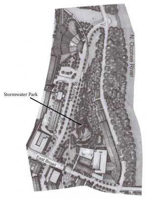
Photo Credit: Jack Crowley
The second potential park space is on public property in the middle of downtown’s River District where new residential and mixed-use projects are being built. Presently, the site can be characterized as being a large hole with a stormwater management facility at the bottom. Yet the location is across Hickory Street from the Intermodal Center and abuts the 909 East Broad and The Eclipse residential sites. It’s also across East Broad Street from the Firefly trailhead and the proposed extension of the bicycle/pedestrian corridor through this park site on the way downtown at Dougherty Street.
The model for this proposed green space is Glenwood Park east of downtown Atlanta along Interstate 20, which is similar both in size and depth of excavation. The park in this newly designed urban village serves both stormwater management and green recreational space. Another, larger example is the Fourth Ward Park along Atlanta’s BeltLine off of Ponce de Leon Avenue.
The park proposal also affords a relocation site at the corner of East Broad and Hickory streets for the iconic former Jittery Joe’s Roasting Co. building that is located directly across the street, uncomfortably below the sidewalk level. This building can be repurposed for the arts, a coffee shop, restaurant, pub or park-related activities. It likely will be vulnerable to the redevelopment of its present location. On public land, income from its ground lease could be earmarked for park programming, operations and maintenance.
This park site is very central to the emerging community being developed in the River District, and it is ideally accessible by pedestrian, bicycle, auto and transit transportation. Its north end at Hickory and Willow makes it a downtown appendage of the North Oconee Greenway.
In any case these are two more ideas that I’ve just run up the flagpole, in the Flagpole! I hope they fly.
Like what you just read? Support Flagpole by making a donation today. Every dollar you give helps fund our ongoing mission to provide Athens with quality, independent journalism.